Other goals are partially met. Between fully completed goals and partially completed goals, the City has finished 50% of the Open Space Plan. We are making good time. The City is halfway finished with the Open Space Plan goals, and we still have 6 years to go.
This progress is thanks to both City-led initiatives and the fantastic work done by our partners like the Kingston Land Trust, the NYS Department of Parks, Recreation, and Historic Preservation, Radio Kingston, and all of you who helped plant new trees in Kingston.
Check out this clip from the Northeast Natural History Conference in April, where NYS DEC Conservation and Land Use Specialist Nate Nardi-Cyrus showcases Open Space Plan successes in the City of Kingston:
-------
On September 25th, the City of Kingston and the CAC hosted the first Open Space Plan Public Workshop, with public input accepted following the meeting.
Open Space Public Workshop General Information, Project Timeline
Workshop Presentation
Workshop Notes
A draft Open Space Plan is expected to be available for review in the first half of 2019.
Natural Resource Inventory
FINAL Natural Resources Inventory- Narrative

FINAL Natural Resources Inventory Maps
Aquifers
Bedrock Geology
City Owned Properties
Forests
Forsyth Park Complex
Historic and Cultural Assets
Kingston Point Park
Major Ecological Features
Regional Context
Rondout/Chestnut Historic Districts
Rondout Creek Mouth
Shoreline Habitat
Shoreline Type
Signficant Habitats
Soils Geology
Streams/Floodplains
Surficial Geology
Vacant Parcels
Wetlands
Additional Maps
Land Surface Temperature Map
This map was produced by the Reinmann Lab at the CUNY Advanced Science Research Center using land surface temperature data from NASA’s ECOSTRESS satellite. The data are in their native 70-m resolution and represent one cloud-free time period. It is important to note that these data are for land surface temperature, not air temperature. While there are good correlations between land surface temperature and air temperature, they are not 1:1.
FINAL Open Space Index Maps
City of Kingston Parcels Greater than or Equal to 5 Acres
Principle Aquifers
Biologically Important Areas- Aquatic
Biologically Important Areas- Terrestrial
City of Kingston Owned Parcels
FEMA Floodplains and Flood Ways
Matrix of Dominant Habitat (Urban Forest)
Parcels of Historical Value
Parcels Adjacent to Historical Properties
Park Potential
Parks
Parcels Adjacent to Parks
Regions within 1/4 mile of Parks
Regions outside 1/4 mile of Parks
Riparian Buffers
Parcels within 100' of SAV Beds
Steep Slopes
Surface Water
Terrestrial Corridors
Tree Canopy
Vernal Pools
Wetlands and Hydric Soils
Public Review Process
The City of Kingston, in collaboration with the Kingston Conservation Advisory Council and the Kingston Tree Commission, held a special presentation that introduced the city’s Natural Resources Inventory (NRI) maps and data, as well as the city’s Street and Park Tree Inventory. The public meeting was held on Tuesday, June 26th from 6:00-8:00 p.m., at the City Hall Common Council Chambers.
The meeting was designed to introduce the public to the many natural assets within the City of Kingston, displayed on user-friendly maps and compiled into data sets. This meeting served as a presentation of findings, as well as information solicitation from attendees, to best inform the completion of the next phase of the project: an Open Space Plan for the City of Kingston. Participation and feedback was encouraged both during the meeting as well as following. Doors opened at 6:00pm to allow individuals to review maps and speak directly with project staff; a formal presentation began shortly thereafter followed by an opportunity for the public to provide input and ask questions.
The City of Kingston, NY - Natural Resources Inventory, June 2018, was prepared by John Mickelson, of Geospatial & Ecological Services, consultant for the City of Kingston.
This project was funded in part by a grant from the New York State Environmental Protection Fund
through the Hudson River Estuary Program of the New York State Department of Environmental Conservation (NYSDEC) to the City of Kingston, NY.
Natural Resources Inventory Project Team:
Emilie Hauser, Kingston CAC Vice Chair
Kevin McEvoy, Kingston CAC Secretary and Kingston Land Trust
Julie Noble, City of Kingston Environmental Education and Sustainability Coordinator and Kingston
CAC Chair
John Mickelson, consultant to the project, Geospatial & Ecological Services
Contributors:
Special thanks to Mayors Steve Noble and Shayne Gallo, former Economic Development Director and CAC member Gregg Swanzey; Laura Heady, Ingrid Haeckel and Emily Vail, NYSDEC Hudson River Estuary Program; Gretchen Stevens and Chris Graham, Hudsonia Ltd.; Matthew Akin and Krista Micelli, SUNY New Paltz; Jennifer Schwartz Berky, Hone Strategic LLC; Scenic Hudson; Town of Rosendale CAC; Town of Hurley CAC; Kingston Parks and Recreation Department; Julia Farr and Tim Weidemann, Kingston Land Trust; City of Kingston Assessor’s Office; Amanda LaValle, Dennis Doyle, Rick Umble and Tom Hines, Ulster County; NYSDEC Hudson River Estuary Program
Conservation Advisory Committee Members during the time of the NRI project
* Current members
Casey Schwarz * Judith Deming
Lorraine Farina * Felipa Gaudet
Betta Broad * Valeria Gheorghiu
Lynn Johnson* Susan Hereth
Diane Bonavita Sophie Dolamore
Lillian Childress Elizabeth Higgins
Karen Corey Arthur Zaczkiewicz
PUBLIC INPUT Process
The City of Kingston and the Kingston CAC accepted public comment on the DRAFT Natural Resources Inventory until July 23rd, 2018.
Comments
We were looking for two kinds of feedback:
1. Do you feel strongly that the NRI *missed* an important natural resource or open space item, system, place or topic? If so, please:
a. Name it
b. Describe it and
c. Tell us what components or parts of it you feel should have been included (remember; this is the *inventory* part of the project, of itemizing and cataloging the important natural resource and open space resources. Solutions and conservation measures will be tackled within the Open Space Plan, which you'll also have opportunities to engage with).
2. Do you feel strongly that the NRI got an item or items significantly *wrong* or that there was a mistake within the components that were included? If so, please:
a. Name the place, system, component or feature
b. Describe what aspect, metric or sub-component you feel was presented in error
c. Detail what you feel that that part *should* have been or should be corrected to reflec
Background
Since May 2011, a CAC sub-committee has been in the process of developing a Natural Resource Inventory (NRI) for Kingston. An NRI is a survey of the natural resources in a community, with the goal of informing the planning board, common council and decision makers on land use decisions. This is done by:
(1) Gathering existing digital data layers and sectioning out the data for Kingston including such data as: Surface waters, Geology, Flood zones, Soil, Agricultural Lands, Vegetated Lands, Forests, Ecologically Sensitive Areas, Parks and Recreational Areas, and Developed Areas,
(2) Gathering any data that is missing or not mapped,
(3) Compiling and creating map layers that will visually demonstrate and inform decision makers in land use decisions. For example: Environmental Justice Areas, Walking/Biking Routes, Complete Streets, Watersheds, Potential Garden/Park Space,
Land Use Changes, Green Infrastructure Potential, Renewable Energy Potential, Brownfield Sites.
The Kingston CAC is working with the Town of Rosendale CAC, Scenic Hudson, Ulster County, the Kingston Land Trust, Kingston Parks and Recreation, Hudsonia, and local initiatives and organizations to gather the information and create a useful database, with a set of maps and recommendations.
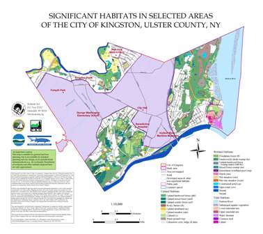
Significant Habitats Map
Hudsonia, Ltd, has mapped the Significant Habitats in the City of Kingston. The areas mapped include the Northwest, East and South portions of Kingston, which have the largest continuous open space. The more urban center of Kingston was not mapped. This data represents, by polygon, habitats of significance in Kingston, including upland, tidal and wetland habitats. Significant Habitats Map
Habitat Summary
Natural Areas and Wildlife in Your Community
In May 2014, at the request of the CAC, the Hudson River Estuary Program created a Habitat Summary for Kingston. This is an overview of significant ecological systems present in our community. Habitat Summary
This document was created by the New York State Department of Environmental Conservation’s Hudson River Estuary Program and Cornell University’s Department of Natural Resources.This is an overview of significant ecological systems present in our community. This summary was completed to provide information for land‐use planning and decision‐making as requested by the Kingston CAC. It identifies significant ecosystems in the city, including streams, forests, wetlands, shoreline habitats, and other natural areas with important biological values. This summary is based only on existing information available to the New York State Department of Environmental Conservation (DEC) and its partners, and, therefore should not be considered a complete inventory.
Summary Content
This summary includes complementary text, maps, and tables. The Habitat Summary text describes what is known about the city’s important natural areas and habitats and has the same headings as the maps. It details the information in the maps, including the ecological importance of the data and its sources. There are eight habitat maps for the City of Kingston, which follow the text:
Figure 1: Regional Context of Kingston, NY
Figure 2: Major Ecological Features in Kingston, NY
Figure 3: Streams and Watersheds in Kingston, NY
Figure 4: Wetlands in Kingston, NY
Figure 5: Large Forests (≥ 200 acres) in Kingston, NY
Figure 6: Hudson River Shoreline Habitat in Kingston, NY
Figure 7: Hudson River Shoreline Type in Kingston, NY
Figure 8: Shoreline Habitat at Mouth of Rondout Creek in Kingston, NY
Descriptions of grassland, shrubland, and young forest habitats are included in the text but not mapped.
Following the maps, Tables 1 and 2 list known species and habitats of conservation concern that have been recorded for Kingston.
Table 1: State Rare Plants, Animals, and Ecosystems in Kingston, NY
Table 2: Significant Birds in Kingston, NY
At the end of the summary, the References section lists the sources of information used to develop this document and places to find more information. General conservation measures for protecting natural areas and wildlife are also provided.
Preliminary Natural Resource Review
The Preliminary Natural Resource Review, completed by the Kingston CAC, includes a comprehensive approach to open space objectives and an open space preservation program made up of ten goals that considers water resources protection, preservation of wildlife habitat, the identification and retention of historic resources and the management of parks and recreation facilities and the management of community and urban forestry and agriculture. Besides complementing the Habitat Summary, the Preliminary Natural Resource Review gives additional definition to the Significant Habitat Map prepared by Hudsonia.
Goal 1: Preserve and enhance the natural and cultural features that form Kingston’s unique qualities.
Goal 2: Promote a land use development pattern that is consistent with the carrying capacity of natural resources and the ability to provide services.
Goal 3: Ensure the quality of Kingston’s water resources.
Goal 4: Protect and promote urban agriculture, community and urban forests and forested land.
Goal 5: Retain forested areas, stream corridors, wetlands and other open spaces to the maximum extent practical, so as to establish and preserve buffers between developed areas.
Goal 6: Provide increased protection for environmentally sensitive areas such as wetlands, floodplains, steep slopes, ridges, wildlife habitat areas and corridors, and unique geological formations and features.
Goal 7: Preserve the character of historical sites and structures.
Goal 8: Protect, expand, connect and create active and passive recreational facilities andopportunities.
Goal 9: Identify and protect scenic views as seen from roadsides, parks, waterfronts, and other areas frequented by the public.
Goal 10: Preserve and enhance key entryways or gateways to Kingston.
Technology in Planning and Environmental Analysis
On Thursday, January 22, 2015, the Kingston Planning Board and the Kingston CAC held a joint meeting, at 6:00pm in Kingston City Hall. Meeting Agenda Meeting Minutes
At this meeting, Amanda LaValle, Dennis Doyle, Rick Umble, and Laura Heady presented tools for land use planning to the two boards. Their presentations are here:
1) Technology in Planning and Environmental Analysis, A presentation by Ulster County Departments of the Environment, Planning and Information Services on Web-Based Planning Tools
2) Habitat Map and Habitat Summary: Planning Tools for the City of Kingston, by Laura Heady of the DEC Hudson River Estuary Program.
This information, along with the GIS database of natural resource layers will be integrated into a formal Natural Resource Inventory and ultimately an Open Space Plan for Kingston. For more information about this NRI initiative, contact Emilie Hauser, CAC member or Julie Noble, City of Kingston: [email protected]